Americans love cars and they love road trips! Nearly everyone who grew up in the U.S. has a fond memory of loading up the family, the gear, and the snacks, and getting out on the road.
Even if it’s just going to grandma’s house an hour away, road trips offer a feeling of freedom, excitement, and adventure.
Recently there was a popular post that went viral called “The Ultimate 13,699-Mile American Road Trip.” The route was designed to go through all 48 states and hit as many landmarks as possible:
“If you're planning a summer road trip and want to go big, a computer science Ph.D. candidate just mapped out the ultimate cross-country drive. You'll hit the biggest landmarks in all 48 states on a course that's absolutely as efficient as possible.
The route allows you to start anywhere along the path and hits some of the best sites in the country: the Alamo in Texas, the French Quarter of New Orleans, and Frank Lloyd Wright's Taliesin in Wisconsin.”
As impressive as this route is, it seemed a bit too long and missed out on some iconic American drives like the Pacific Coast Highway, Route 66, and the Overseas Highway, just to name a few.
We at Experiencify recently put together a collection of the world's best road trips, and that inspired us to come up with an epic cross-country American road trip. In our research, we identified a number of scenic and iconic highways, byways, and drives in America. We wanted to see how many of these we could link together to create one long awesome road trip.
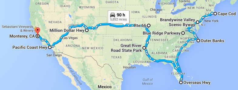
The result is our Super Ultimate Epic American Road Trip. It takes you 5,892 miles cross-country from Cape Code, MA to Monetery, CA. On the way, you’ll experience nine of most scenic and iconic stretches of highway and byway our country has to offer.
Here’s what the full route looks like, along with the step by step Google Map directions. We’ll walk you through it in three phases: Northeast, Southeast, and Central/Western.
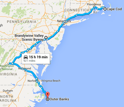
Phase I: Northeast
Start: Cape Code, MA
Finish: Outer Banks, NC
Scenic Routes Driven: Cape Cod Scenic Drive, Brandywine Valley Scenic Byway, and Blue Ridge Parkway
Total Distance / Time: 921 miles / 15 hours
Route: Google Map directions
 Cape Cod Scenic Drive:
You’re going to start your adventure in Cape Cod, MA. Along the Cape Cod Scenic Drive, you’ll enjoy vistas, bike paths, historic villages, museums, beaches, Nickerson State Park, and Cape Cod National Seashore.
Brandywine Valley Scenic Byway:
After enjoying Cape Code, you’re going to make your way southwest. When you get to Delaware, you’re going to take a little 8-mile detour to explore the Brandywine Valley Scenic Byway.
This narrow twisting road along the Brandywine River offers access to historic sites, magnificent estates, glorious gardens, and mesmerizing museums from the du Pont family.
From there, you’re going to continue southwest along I-95 S / I-495 W passing through Baltimore, MD and Washington, DC. Washington would be a great place to stop and visit the US Capitol, Smithsonian Museums, the Great Mall, and the Lincoln Memorial.
Blue Ridge Parkway:
Afterwards, you’ll continue southwest until you get to Charlottesville, Virginia where you’ll take a 22.5 mile detour along the Blue Ridge Parkway. Known as “America’s Favorite Drive,” it meanders along the Blue Ridge Mountains and offers stunning views, abundant hiking trails, picnic areas, campsites, and interpretive exhibits.
You’ll next travel southeast through Richmond, Norfolk, and Virginia Beach until you get into North Carolina and the Outer Banks.
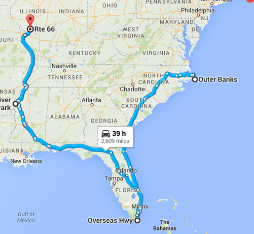
Phase II: Southeast
Start: Outer Banks, NC
Finish: Route 66 in Illiinois
Scenic Routes Driven: Outer Banks Scenic Byway, Overseas Highway, and Great River Highway
Total Distance / Time: 2609 miles / 39 hours
Route: Google Map directions
Outer Banks Scenic Byway:
The coastal landscapes along the Outer Banks Scenic Byway offer tidal marshes, wind swept dunes, lonesome beaches, and beautiful sounds. Cape Hatteras and Cape Lookout are home to four lighthouses, and Pea Island and Sea Island are wildlife refuges with migrating songbirds and waterfowl.
Overseas Highway:
From the Outer Banks, you’re going to go due West on US-64 to I-95 South, which you’ll take all the way down to the Florida Keys. Along the way, you’ll pass through Savannah, GA, Jacksonville, Daytona Beach, Fort Lauderdale, and Miami.
The Overseas Highway traverses a number of bridges and causeways giving you the feeling of piloting a hovercraft across the ocean. Along the route you can stop at a variety of seafood restaurants and swim with dolphins at the Theater of the Sea.
Great River Highway:
After enjoying the Florida Keys, you’ll head back north along I-75 N and I-10 W, passing through Orlando, Tallahassee, and Mobile, MS. You’re going to head north in Mississippi for a couple hours until you get to the Great River Road State Park.
You’ll drive along the Great River Highway, which runs along the mighty Mississippi River. It goes through Memphis, TN, St Louis, MO, and passes through hundreds of small river towns where you can explore their culture, history, food, and music.
This road goes all the way north to Minnesota, but you’re going to only take it to Illinois, where you’ll be getting on iconic Route 66.
Phase III: Central / West
Start: Route 66 in Illinois
Finish: Monterey, CA
Scenic Routes Driven: Route 66, Million Dollar Highway, and Pacific Coast Highway
Total Distance / Time: 2361 miles / 36 hours
Route: Google Map directions
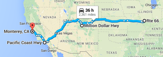
Route 66:
You’re only going to be on Route 66 for a couple of miles so you can get a feel for it. Built in 1926 and known as “Will Rodgers Highway,” this 2-lane road is one of the most iconic of our country’s byways.
Route 66 officially no longer exists on modern maps, but you can still piece it together with this map. If you want to take it for a longer stretch, you can take it to Springfield or Joplin, MO and then cut back up to I-70 West from there.
Million Dollar Highway:
Once you get back on I-70 West, you’ll take that through Kansas City, all the way through Kansas, and into Colorado.
Just outside of Denver, you’re going to take a little detour south to check out the Million Dollar Highway. The breath-taking section of US Highway 550 climbs more than 2 miles above sea level and provides countless scenic vistas through the San Juan Mountain area of the Rockies.
Pacific Coast Highway:
You’re going to get back on I-70 West, which turns into I-15 S in Utah, and takes you all the way to Los Angeles, CA. Along the way, you’ll pass through Las Vegas, which gives you a perfect opportunity to take a break and enjoy yourself for a bit.
From the LA area, you’re going to I-5 North to US-101 North and eventually to Monterey. The sweet spot of the Pacific Coast Highway is about 123 miles long from Monterey south through Carmel and Big Sur, where mountains and cliffs butt up against the Pacific. Feel free to explore as much or as little of this amazingly scenic roadway as you like.
What Next?
Monterey is the end point of our Super Ultimate Epic American Road Trip, but you have a variety of options from there. Here are some options:
San Francisco -- Drive up to SF, which is about 120 miles or 2.5 hours from Monterey.
Oregon & Washington -- There are a couple of iconic and scenic roads that you may want to explore in the Pacific Northwest if you have time. One is the Columbia River Scenic Byway, a 75-mile picturesque drive in Oregon. And the other is the Olympic Peninsula Loop, a 330-mile loop around Washington state’s Olympic Peninsula.
Drive back to the East Coast -- If you’re finished sight seeing and want to get back to the East Coast, the most direct route from San Francisco to Boston is via I-80 East. It’s 3100 miles and will take you a total of about 45 hours.
Fly back to the East Coast -- If you were smart enough to rent a vehicle for your cross-country adventure, you can just hop on a plane from SFO to the East Coast. For tips on renting a vehicle for cross country trips, see here.
Even if you can’t do the full Super Ultimate Epic American Road Trip, we hope you’ll explore the parts that are closest and most accessible to you.
There’s nothing like exploring our beautiful country by car, motorcycle, or RV. Strap yourself in, put Born to be Wild on your CD player, and enjoy the open road!
Find & Create Your Moonshot in Life - Retire By 45
[…] visit as much of it as possible. Rent an RV and really explore. Check out my blog post for the most epic US road trip for […]